
View the PDF here
National Research Council of Canada releases first National Guide for Wildland-Urban Interface Fires
By: Allison Mills and Noureddine Bénichou, Construction Research Centre, National Research Council of Canada
When wildfires spread into the wildland-urban interface (WUI), an area where houses and other human developments meet or are mixed with wildland vegetation, the consequences can be extreme.
In the last decade, WUI fires in Canada have resulted in the loss of over 2,400 structures, with an insured loss of C$4.5 billion (US$3.7 billion). The 2016 Horse River fire was the most expensive disaster in Canadian history. When the fire spread into Fort McMurray, Alberta, and neighbouring communities, it destroyed nearly 1,600 structures, resulting in an insured loss of C$3.8 billion (US$3.1 billion), and forced the evacuation of more than 80,000 people [1].
The threat posed by WUI fires is growing as urban areas expand into wildlands, rural areas increase in population, and wildfires become more frequent and severe due to climate change (see Canada’s Changing Climate Report for more information [2]). In the coming decades, the risk of WUI fires is expected to increase both in regions of Canada with a long history of wildfires and in those with no such history.
Building wildfire resilience
In 2016, the National Research Council of Canada (NRC) and Infrastructure Canada launched a five-year Climate-Resilient Buildings and Core Public Infrastructure (CRBCPI) initiative to integrate the consideration of climate resilience into building and infrastructure design, guides and codes.
Given the increasing threat of WUI fires in Canada, improving the wildfire resilience of buildings and communities has been one of the initiative’s primary goals. At the outset, an NRC project team, led by Noureddine Bénichou, was formed to find the best path to achieving this goal. The team examined current practices and existing Canadian and international reference documents, and discovered a lack of national wildfire guidance for Canada’s WUI areas.
Seeing the opportunity to fill this gap, the team assembled an international technical committee of experts from government, academia, industry and consultancy to drive the development of a national guide, and established task groups to develop content. Once a draft guide was completed, the team invited stakeholders from different sectors to review and comment on its content. The team anticipated that this inclusive development process would lead to broad acceptance of the resulting guide.
National Guide for Wildland-Urban Interface Fires
|
Figure 1. National Guide for Wildland-Urban Interface Fires.
|
The National Guide for Wildland-Urban Interface Fires (Figure 1), the first of its kind for Canada, is now available for free download from the NRC Publications Archive website [3].
Drawing on recent wildfire research, existing codes, standards and guidelines, and new insights from international experts, the Guide provides comprehensive support for WUI areas across Canada, including recommendations on:
- hazard and exposure assessment
- vegetation management and construction measures
- community planning and resources
- emergency planning and outreach
Hazard and exposure assessment
The first step in applying the Guide is to carry out a hazard and exposure assessment, which allows users to identify the recommendations that will be most beneficial.
In the Guide’s assessment method, the hazard level of a location is determined from a hazard map (Figure 2), provided by the Canadian Forest Service of Natural Resources Canada [4].
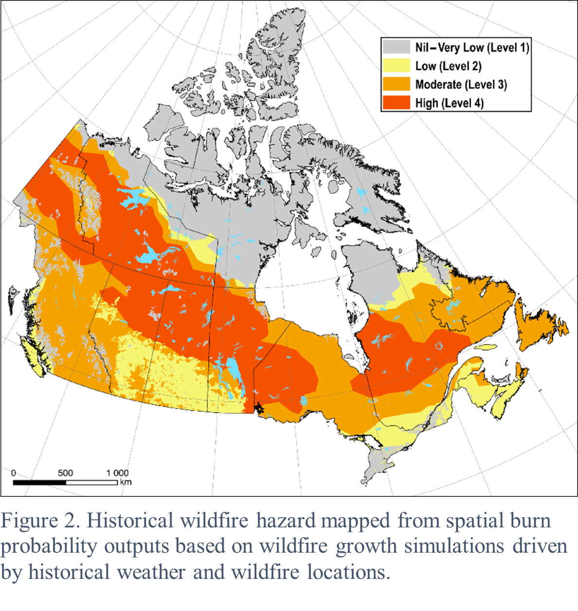
The hazard level, which ranges from Nil–Very Low (Level 1) to High (Level 4), takes into account regional topography, potential fuel and weather conditions, wildfire ignitions, and the possibility of extreme fire behaviour. The Guide’s recommendations are intended for locations with a hazard level greater than Nil–Very Low (Level 1).
To identify recommended building-scale measures, the local exposure level also needs to be determined. The Guide provides both simplified and detailed assessment methods, which are partially based on the FireSmart Wildfire Exposure Assessment [5]. The simplified method considers local fuel conditions and the potential for ember transport, radiant heat or direct flame contact. The detailed method further considers local topographic conditions, fuel percent cover, and hazard level.
The exposure level, which ranges from Nil to High, indicates the potential for exposure to ignition sources if a high-intensity fire occurs nearby. The Guide’s building-scale measures are intended for buildings with an exposure level greater than Nil.
Vegetation management and construction measures
The exposure level is used to determine which of the vegetation management and construction measures outlined in the Guide are recommended for the WUI fire protection of a particular building.
The vegetation management measures include recommendations for landscaping, fuel removal or reduction, firebreaks and setbacks. The construction measures include recommendations for exterior walls and cladding, roofs, foundation walls, supporting elements for raised or elevated buildings, doors and windows, and decks, balconies and porches.
To determine which construction measures are recommended, the building is assigned a construction class (CC), ranging from CC1(FR) to CC3, on the basis of its exposure level and the extent to which vegetation management is applied up to 100 metres (approximately 300 feet) from the building.
If vegetation management extends further from the building, the construction class will be higher and the recommended construction measures will be less stringent. For example, without vegetation management, a building with a high exposure level would be assigned to construction class CC1(FR), and non-combustible external wall cladding would be recommended. With vegetation management extending 100 metres (approximately 300 feet) from the building, the same building would be assigned to construction class CC3, and exterior wall cladding with limited ignition resistance would be recommended.
This means that, in many cases, the construction costs associated with WUI fire protection measures can be reduced by managing the vegetation surrounding the building.
Community-scale guidance
In addition to building-scale measures, the Guide provides community-scale recommendations on community planning and resources, as well as on emergency planning and outreach.
To support community and resource planning in the WUI, the Guide sets out considerations and recommendations for demographic analysis, land use and development, access and egress routes, utilities, public transportation, and firefighting resources. The Guide also sets out considerations and recommendations for evacuation planning, emergency communications, public education, and outreach communications to support emergency planning and outreach in the WUI.
This extensive guidance will enhance community protection from and resilience to WUI fires.
Impact
On the whole, the measures recommended in the Guide will help to minimize the impact of WUI fires by reducing their likelihood and severity, inhibiting their spread, and improving the effectiveness of community response.
Users can currently choose to implement the Guide’s measures on a voluntary basis. The NRC project team will be working towards converting the Guide into a standardized document that could be adopted by communities, provinces or territories.
The implementation of the Guide’s recommendations is expected to save lives, protect homes, businesses and communities, and reduce the long-term cost associated with human developments in the WUI. An impact analysis report prepared for the NRC by the Institute for Catastrophic Loss Reduction (ICLR) indicates that, by adopting the Guide across Canada, approximately $4 would be saved for every $1 spent on mitigation [6]. The potential cost savings are predicted to increase with climate change.
According to the ICLR report [6], “Satisfying the National WUI Guide’s recommendations appears to offer benefits that greatly exceed its costs. The benefits come from avoiding future property and life-safety losses.”
The Guide is a valuable resource for anyone wanting to improve the wildfire resilience of buildings or communities in the WUI, including local governments and authorities, planners, emergency managers, developers, insurers, and property owners. With this resource, the WUI areas of Canada will be better able to adapt to the increasing frequency and severity of wildfires in the changing climate.
References
- For references for the data in this paragraph, see Table 1 in [3].
- Bush, E. and Lemmen, D.S., editors. (2019). Canada’s Changing Climate Report. Government of Canada: Ottawa, ON. 444 pp. Available at ChangingClimate.ca/CCCR2019.
- Bénichou, N., Adelzadeh, M., Singh, J., Gomaa, I., Elsagan, N., Kinateder, M., Ma, C., Gaur, A., Bwalya, A., and Sultan, M. (2021). National Guide for Wildland-Urban Interface Fires. National Research Council of Canada: Ottawa, ON. 192 pp. Available at https://doi.org/10.4224/40002647.
- Provided by the Canadian Forest Service, Natural Resources Canada. Created as output from a project funded by a Canadian Safety and Security Program grant to X. Wang and S.W. Taylor (CSSP-2016-CP-2286).
- Beverly, J., Braid, G., Chapman, L., Kelm, S., Pozniak, W., Stewart, L., Johnston, K. (2018). FireSmart Wildfire Exposure Assessment: A planning Tool for Identifying Values at Risk and Prioritizing Mitigation Effort. FireSmart Canada. 28 pp. Available at https://wildfireanalytics.org/community-fire-exposure.html.
- Porter, K.A., Scawthorn, C.R., and Sandink, D. (2021). An Impact Analysis for the National Guide for Wildland-Urban Interface Fires. Prepared for the National Research Council of Canada. Institute for Catastrophic Loss Reduction: Toronto, ON. 136 pp. Available at https://doi.org/10.4224/40002649.