Avoiding Dire Wildfire Evacuations with Probabilistic Trigger Boundaries
By: Nikolaos Kalogeropoulos, MEng, PhD student, Imperial College London, Harry E. Mitchell, PhD, Imperial College London, Guillermo Rein, Professor of Fire Science, Imperial College London
View full PDF here
Wildfires are an ever-present threat to communities around forested regions, and timely evacuations are critical to saving lives. Yet even well‐intentioned evacuation orders can backfire if issued too late, resulting in dire evacuations where people evacuate without enough time to do so safely. Our recent work [1] presents a rigorous framework to define and predict dire evacuations using probabilistic trigger boundaries. By coupling wildfire spread models with evacuation dynamics, we introduce an evacuation safety factor that quantifies the risk of a dire evacuation. This new approach was applied to the tragic Mati fire of 2018 in Greece, where delayed action contributed to 104 fatalities.
Evacuation is the last protection layer when a wildfire approaches a community. Initiating an evacuation too late can have disastrous consequences. The safety of an evacuation hinges on two key time metrics [2], [3], [4], [5]:
- Wildfire Required Safe Egress Time (WRSET): The time taken by evacuees to reach a safe location
- Wildfire Available Safe Egress Time (WASET): The time at which tenability criteria are exceeded by the environmental conditions
A safe evacuation occurs when the available time (WASET) exceeds the time needed (WRSET). When these times converge or when WRSET exceeds WASET, an evacuation becomes “dire”, and there is a significant chance that not everyone will be able to escape safely.
Despite the critical nature of these timings, no standard framework has existed to define when an evacuation is too late. Existing protocols have relied on retrospective assessments after casualties occur. Our work fills this gap by developing a quantitative method to predict dire evacuations before they happen.
Our methodology builds on the concept of trigger boundaries—imaginary perimeters around a community where the wildfire’s travel time equals the community’s required evacuation time [6], [7], [8]. In practical terms, the trigger boundary marks the last moment when an evacuation order can be issued with confidence that the community can clear the area safely.
Traditional models provide a single, deterministic boundary. However, both wildfire spread and evacuation times are influenced by numerous uncertain factors such as wind conditions, fuel moisture, traffic dynamics, and human behavior. By treating WRSET and WASET as probabilistic variables, we can derive a more realistic, probabilistic trigger boundary. This boundary is not a single line but a contour with varying hues that reflect the uncertainty in fire behavior and evacuation response.
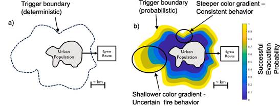
Figure 1: a) Example of a deterministic trigger boundary surrounding an urban area [10]. b) The same area with probabilistic trigger buffers. Probabilistic trigger boundaries highlight areas with higher or lower risk, where the fire behaviour is more or less variable respectively [1], [9]
Central to our framework is the evacuation safety factor (SF) [1], [10]. This metric quantifies the probability that an evacuation will be successful. In our formulation, the safety factor is defined as a function of the difference between the probabilistic estimates of WASET and WRSET, normalized by their combined uncertainty. Because wildfire and evacuation processes are inherently continuous, the safety factor will always be less than 1. To make this measure more actionable, we introduce a calibrated scale where values greater than 1 indicate a safe buffer and values approaching 0 represent an imminent risk of entrapment. This safety factor provides decision-makers with a quantitative tool to assess when an evacuation order is no longer likely to ensure complete safety.
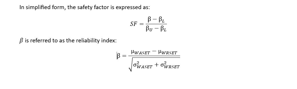
With defined by the 95th percentile of the β value, and defined by. is the cumulative distribution for the standard normal variable. This analysis applies to the intersection of two normally distributed variables.
Here, μ and σ represent the mean and standard deviation of WASET and WRSET, respectively. An SF of 1 indicates that an evacuation is fully safe, whereas an SF below 1 suggests that the risk of a dire evacuation increases.
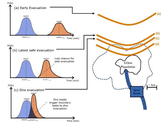
Figure 2: A probabilistic illustration of evacuation (WRSET) vs. wildfire (WASET) progress towards a community. The ratio of the two provides a safety factor (SF) of evacuation, with values greater than 1 leading to safe evacuations and values less than 1 leading to dire evacuations. The SF continuously decreases as the evacuation is delayed. At time (a) the wildfire is far enough from the community that there is no chance of a dire evacuation (SF > 1). At time (b) the fire is close enough where there is the last instance of SF ≥ 1 , meaning this is the last opportunity to call an evacuation with zero risk of entrapment. At time c) the wildfire is close enough that it is now a possibility that a dire evacuation will occur (SF < 1). [1]
The Mati fire in Greece serves as a poignant case study for our approach. On July 23, 2018, a wildfire ignited near the Mati settlement, driven by abnormally dry fuels and strong, gusty winds. With an average spread rate of 35 m/min and occasional bursts up to 110 m/min—the wildfire advanced rapidly toward the community. Critically, due to a combination of late detection and a suboptimal road network, the evacuation in Mati was initiated too late. Our retrospective analysis shows that from the moment of wildfire detection, the evacuation safety factor was significantly below 1, indicating a dire evacuation scenario.
Using FlamMap for wildfire simulations and incorporating CORINE Land Cover data for vegetation classification, we generated over 500 wildfire scenarios. For the evacuation component, we relied on data from four independent simulation studies that produced WRSET values ranging from 57 to 89 minutes. Although the evacuation data is limited compared to the wildfire simulations, it provided a basis to approximate the WRSET distribution using a normal distribution with a mean of 75 minutes and a standard deviation of 6 minutes.
By converting the wildfire rate of spread (ROS) data from our simulations into WASET estimates and comparing these to the WRSET values, we could construct histograms that describe the probabilistic nature of available egress time. Our analysis confirmed that as the wildfire approaches the community, the variance in WASET decreases, reflecting less uncertainty in the fire’s imminent arrival. In contrast, the evacuation time remains variable due to human behavior and logistical factors.
The 2018 Mati fire in Greece provides a stark example of a dire evacuation. Ensemble wildfire simulations (500 in total) were conducted using FlamMap to model the wildfire’s rate of spread. Histograms of ROS were generated and subsequently converted into WASET distributions. Meanwhile, limited evacuation simulations (four in number) were used to characterize WRSET with an assumed normal distribution (mean ≈ 75 min, standard deviation ≈ 6 min).
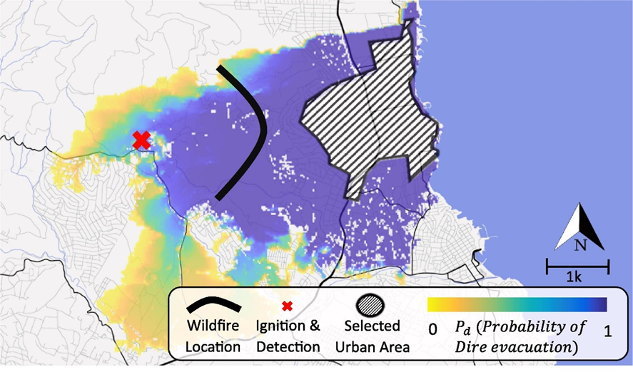
Figure 3: The probabilistic trigger boundary for the 2018 Mati area. The wildfire location denotes the approximate position of the wildfire when spontaneous evacuations of Mati started. The evacuation started with a Safety Factor very close to zero, resulting in a dire evacuation. [1]
When the wildfire was first detected, analysis revealed that the safety factor was already below 1. Retrospective mapping of the probabilistic trigger boundary showed that by the time the evacuation order was issued, the wildfire was already too close to the community, confirming the dire nature of the evacuation. This analysis not only quantifies the temporal window available for safe evacuation but also underscores the potential of probabilistic trigger boundaries as a tool for pre-event planning.
The development of an evacuation safety factor provides a systematic way to quantify the dire nature of an evacuation. Unlike binary assessments of success or failure, this method captures the continuum of risk based on the evolving overlap between WASET and WRSET. The probabilistic trigger boundary then serves as an operational tool: by mapping this boundary in real time, emergency managers can pinpoint the critical moment at which an evacuation order must be issued to avoid dire outcomes.
Importantly, this methodology also paves the way for a risk-based approach that not only assesses the likelihood of a dire evacuation but can also be extended to estimate its potential severity (e.g., injuries and fatalities). As wildfire behavior and evacuation dynamics are intrinsically linked, future work should explore coupled models that account for factors such as traffic congestion and the effects of smoke on both fire spread and evacuation mobility.
The development of an evacuation safety factor based on probabilistic trigger boundaries represents a major step forward in wildfire evacuation research. Our analysis of the 2018 Mati fire demonstrates that by treating both the wildfire spread and evacuation process as probabilistic phenomena, we can quantify the risk of a dire evacuation before it happens [1]. In the case of Mati, the trigger boundary analysis shows that by the time the fire was detected, the window for a safe evacuation had already closed.
For communities facing the increasing threat of wildfires, adopting such a data-driven approach could mean the difference between a safe evacuation and a disaster. Probabilistic trigger boundaries not only help in assessing current wildfire risk but also serve as a vital planning tool for long-term community resilience. By identifying the last safe moment to evacuate and quantifying the risk through a safety factor, our framework offers emergency managers a clear, actionable metric that can guide decision-making in the face of an evolving wildfire.
As wildfires continue to grow in frequency and severity due to climate change and other factors, innovative approaches like ours are essential. We hope that this framework will spur further research and, ultimately, lead to improved evacuation strategies that save lives.
[1] N. Kalogeropoulos, H. Mitchell, E. Kuligowski, E. Ronchi, and G. Rein, ‘Quantifying dire evacuations in case of wildfire using trigger boundaries and case study of the 2018 Mati wildfire in Greece’, Safety Science, vol. 181, Jan. 2025, doi: 10.1016/j.ssci.2024.106691.
[2] E. Ronchi, S. Gwynne, G. Rein, R. Wadhwani, P. Intini, and A. Bergstedt, ‘e-Sanctuary: Open Multi-Physics Framework for Modelling Wildfire Urban Evacuation FINAL REPORT BY’, 2017.
[3] E. Ronchi et al., ‘WUI-NITY: a platform for the simulation of wildland-urban interface fire evacuation’, 2020. [Online]. Available: www.nfpa.org/foundation
[4] E. Ronchi et al., ‘WUI-NITY 2: the integration, verification, and validation of the wildfire evacuation platform WUI-NITY’, 2021. [Online]. Available: www.nfpa.org/foundation
[5] E. Ronchi et al., ‘WUI-NITY 3: Multi-method traffic movement data collection for WUI fire evacuation modelling Final Report by’, 2023. [Online]. Available: www.nfpa.org/foundation
[6] H. Mitchell, S. Gwynne, E. Ronchi, N. Kalogeropoulos, and G. Rein, ‘Integrating wildfire spread and evacuation times to design safe triggers: Application to two rural communities using PERIL model’, Safety Science, vol. 157, Jan. 2023, doi: 10.1016/j.ssci.2022.105914.
[7] P. E. Dennison, T. J. Cova, and M. A. Mortiz, ‘WUIVAC: A wildland-urban interface evacuation trigger model applied in strategic wildfire scenarios’, Natural Hazards, vol. 41, no. 1, pp. 181–199, Apr. 2007, doi: 10.1007/s11069-006-9032-y.
[8] D. Li, T. J. Cova, and P. E. Dennison, ‘An open-source software system for setting wildfire evacuation triggers’, presented at the Proceedings of the 1st ACM SIGSPATIAL International Workshop on the Use of GIS in Emergency Management, EM-GIS 2015, Association for Computing Machinery, Inc, Nov. 2015. doi: 10.1145/2835596.2835600.
[9] N. Kalogeropoulos, H. Mitchell, E. Ronchi, S. Gwynne, and G. Rein, ‘Design of stochastic trigger boundaries for rural communities evacuating from a wildfire’, Fire Safety Journal, vol. 140, Oct. 2023, doi: 10.1016/j.firesaf.2023.103854.
[10] T. J. Cova, D. Li, L. K. Siebeneck, and F. A. Drews, ‘Toward Simulating Dire Wildfire Scenarios’, Natural Hazards Review, vol. 22, no. 3, Aug. 2021, doi: 10.1061/(asce)nh.1527-6996.0000474.